|
|
Hope of Israel Ministries (Ecclesia of YEHOVAH):
The Temple Mount in the City of David: Ancient Authenticating Descriptions
|
The Psalms are part of the many sources describing a natural spring within the temple, including the Letter of Aristeas, the Book of Enoch 25:1, Tacitus, Philo, Erubin 10 of the Mishnah, several biblical passages, and Eusebius. The only spring in the City of David/Jerusalem, is the Gihon Spring at the center of the southeastern hill. Maimonides mentions that the ark was hidden in “deep and winding tunnels underneath the temple,” describing Hezekiah’s tunnel and/or the winding tunnels of the Warren’s Shaft water system of the Gihon Spring. |
by Marilyn Sams
Ancient descriptions of the Jerusalem Temple Mount are incompatible with the current identification and location of it in Jerusalem, which is a long-standing tradition only, entirely dependent on the undocumented proposition that during the time of David or Solomon the northern walls of the City of David/Jerusalem were broken down to append a large northerly extension for the temple and acropolis. Instead, ancient descriptions of the boundaries of the City of David/Jerusalem delimit it to the southeastern hill, with no northerly extension added. The northern wall of the City of David/Jerusalem was still in place during the siege of Pompey in 63 B.C. (Antiquities XIV, 4, 60).
In 1909-1910, Parker and Vincent discovered archaeological remains dated to 3000 B.C. in the Gihon Spring area, affirming the southeastern hill was the original site of the ancient habitations chronicled in the Bible and history (Reich, 2011). In War VI, 10, 438, Josephus mentions an early king of Jerusalem, a contemporary of Abraham:
"But he who first built it was a potent man among the Canaanites, and is in our own tongue called [Melchizedek], the Righteous King, for such he really was; on which account he was [there] the first priest of God, and first built a temple [there], and called the city Jerusalem, which was formerly called Salem."
Another reference in Josephus states the city “was called Solyma, but afterwards they named it Hiersolyma, calling the temple (hieron) Solyma, which, in the Hebrew tongue means 'security'” (Antiquities VII, 3, 67, Loeb translation). The translation of this passage indicates an amalgamation of the city’s former name (Salem) and the word for “temple” to create the new name “Hierosolyma” or “Jerusalem,” because of the temple there.
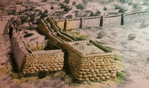
Modern archaeologists Ronny Reich and Eli Shukron uncovered mammoth remains from the Middle Bronze Age II (possibly the era of Melchizedek) in the area of the Gihon Spring. These include the Spring Tower surrounding the Gihon Spring, the Pool Wall guarding the Rock-cut Pool adjacent to it, and the Fortified Passage, which consists of two massive walls forming a path from the Spring and Rock-cut Pool and heading toward the ridge at the top of the slope. These fortifications protected citizens while accessing their major water supply. Reich surmised there was an important fortress at the top of the ridge (Reich, 2011). Since this will be shown to be where Solomon’s temple stood, it also qualifies as the likeliest place for Melchizedek’s temple.
Fig. 1. Artist’s Conception of the Spring Tower, Pool Tower, and Fortified Passage
|
|
Fig. 1. The figure shows an artist’s conception of the Spring Tower, Pool Tower, and Fortified Passage, dated to the Middle Bronze Age II, possibly in the time of Melchizedek. Note the buildings are lying “out” in the Kidron Valley, matching later descriptions for the position of the temple foundations. [Deror Avi, Wikimedia]
The Uru Salem of Abdi-Heba, in the 14th century B.C. and the later city of Jebus also occupied the southeastern hill (Van der Veen, 2013). [i] In the 10th century B.C., after David conquered Jebus, he renamed it the City of David. The northern boundary of the City of David is generally located at Area H of Kathleen Kenyon’s excavations at the bottleneck of the southeastern hill. After Solomon had built the temple and his own house (1 Kings 3:1), “…he made a breach in the wall of the city of David: thus the daughter of Pharoa went up out of the city of David to her house which he built for her” (3 Kings 2:35, Septuagint version). Hence, it is not until after the construction of the temple and Solomon’s palace that an enlargement of the City of David is mentioned, creating what I call the “City of David/Jerusalem.”
In Antiquities VII, 3, 66, Josephus states that David made buildings around the “lower city,” which becomes a synonym for the City of David, after the northerly expansion. The northeastern corner of the City of David/Jerusalem (or the Sheep Gate) probably stood where the southeastern corner of the traditional temple mount stands, or possibly 105 feet north, at the “seam” on the east wall.
Fig. 2. Boundaries for the City of David/Jerusalem
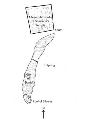 |
Fig. 2. The City of David is the lower half of the southeastern hill, with its northern boundary at the bottleneck (Area H). The City of David/Jerusalem occupied the whole crescent-shaped southeastern hill. The map outlines the ridge area, but the walls were further down the slopes. A northerly extension of the southeastern hill did not begin, as illustrated here, until about 134 B.C.E. when John Hyrcanus built the Baris, which was expanded to become the 36-acre Haram.
To understand there was no northerly appendage added to the southeastern hill, one must start with later descriptions of the City of David/Jerusalem and work back. Although the city had spread to the western hill in Hezekiah’s reign, it shrunk back to the southeastern hill during the Persian era. Even in the Greek era and later, the City of David/Jerusalem is described in the Letter of Aristeas as having its towers arranged “in the manner of a theater;”
Tacitus describes its walls as “bending inwards” (Histories 5.11, as cited in Dissertation 3); Josephus said it had “the shape of the moon when she is horned” (War V, 5, 137); and the Venerable Bede compared it to “an arc,” [ii] each description of the city referring to the crescent shape of the southeastern hill, without any northerly extension appended.
In Antiquities XV, 11, 410, Josephus again uses “in the manner of a theater” to describe the temple lying near to the city, adding that its southern quarter was bounded by a deep valley, both descriptions which refer to the southeastern hill lying against the western hill in the lower Tyropoeon Valley, with the Hinnom and Kidron Valleys on the south and southeast.
In addition, Antiquities XV, 11, 397 says: "The hill [of the temple plaza foundations] was a rocky ascent, that declined by degrees towards the east parts of the city, until it came to an elevated level.” This eliminates the traditional site of the temple mount, since there never has been a city built on its east side, as was the case with the temple mount described by Josephus.
Several descriptions locating the temple on the southeastern hill derive from its being the lowest mountain in Jerusalem. The Venerable Bede noted the temple [ruins] were located in the “lower part of the city” in the vicinity of the “wall from the east,” Eudocia’s 5th century city wall on the east of the southeastern hill. [iii] In Special Laws I.XIII.73, Philo of Alexandria gave a similar topographical description that the temple “…being very large and very lofty, although built in a very low situation…is not inferior to any of the greatest mountains around.” [iv]
In his letter to Faustus, Eucherius (5th Century C.E.), the Bishop of Lyons, said: “The Temple, which was situated in the lower city near the eastern wall, was once a world wonder, but of its ruins there stands today only the pinnacle of one wall, and the rest are destroyed down to their foundations.” [v]
Fig. 3. The Curve of the Southeastern Crescent-Shaped Hill
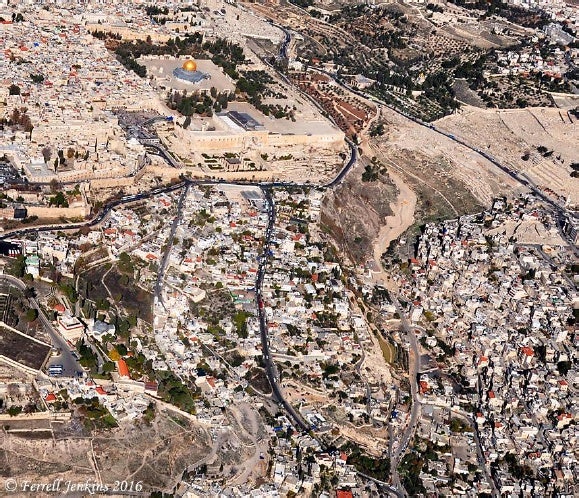 |
Fig. 3. The photo shows how the southeastern hill is curved or “bending back,” like “a moon when she is horned” or would have had its towers arranged in “the manner of a theater.” The Gihon Spring is where buildings begin south of the very steep slopes. Note that the traditional temple mount’s east wall cannot be considered “within the valley,” as described by Josephus. [Courtesy of Ferrell Jenkins]
Further, the Cairo Geniza documents explain that when Omar granted permission to seventy households of Jews to return to Jerusalem, they requested to be near the site of the temple and the water of Shiloah, in the southern section of the city. [vi] The accounts of the temple ruins standing in the lower city or the temple being built in a low situation or in the south are consistent with Josephus’s descriptions of the temple foundations of the east wall being built deep within the Kidron Valley, [vii] not upslope as is the case with the traditional temple mount. In fact, in Josippon ben Gorion’s version of War, he says that from the top of the temple’s east wall, the water in the Kidron Brook could be seen running at one cubit’s distance from the wall.
The southeastern hill location of the City of David/Jerusalem is also affirmed by descriptions of both the Gihon Spring and the temple being in the middle of the city. In Contra Apion I, 22, 198, Hecateus of Abdera (4th Century B.C.) mentioned the temple measured 150 feet by 500 feet in the middle of the city. This being the case, a location for the temple on a northerly extension is not possible. Coincidentally, the Jerusalem Talmud says Shiloah was also in the middle of the city (Hagigah 76a). [viii] In the Letter of Aristeas, from his standpoint on the citadel, looking down into the temple, he describes upper and lower crossroads, implying the city was bifurcated by the temple. This is also implied by the injunction in the Mishnah (Berachot 9:5) that the temple should not be used as a shortcut.
Several scriptures refer to the temple in the “midst” of the city, including Psalm 46:4-5: “There is a river, the streams whereof shall make glad the city of God, the holy place of the tabernacles of the most High God is in the midst of her….” (the river being derived from the waters of the Gihon Spring); Psalm 116:18-19: “I will pay my vows unto the LORD now in the presence of all His people, In the courts of the LORD’s house, in the midst of thee, O Jerusalem;” Zechariah 8:3: “Thus saith the LORD; I am returned unto Zion, and will dwell in the midst of Jerusalem: and Jerusalem shall be called a city of truth; and the mountain of the LORD of hosts the holy mountain.” [ix] Hence, these ancient descriptions verify the city associated with the temple occupied only the southeastern hill.
The Psalms are also part of the many sources describing a natural spring within the temple, including the Letter of Aristeas, the Book of Enoch 25:1, Tacitus, [x] Philo, [xi] Erubin 10 of the Mishnah, several biblical passages, [xii] and Eusebius. [xiii] The only spring in the City of David/Jerusalem, the Gihon Spring at the center of the southeastern hill, was presumably named after the river originating in the Garden of Eden (Genesis 22:2), adding to the Garden of Eden symbolism in the temple above it. In addition, Eusebius called it “the high priest’s fountain,” [xiv] and Philo of Alexandria believed the pomegranates on the high priest’s robe symbolized the “flowing of the stream,” alluding to the living waters of the Gihon Spring. [xv]
The Jewish Encyclopedia notes that when the priests were obliged to eat large quantities of sacred meat, they drank of the water of Shiloah to aid digestion (Ab. R. N. xxxv.), implying its accessibility within the temple. [xvi] Also of note is Maimonides’s mention that the ark was hidden in “deep and winding tunnels underneath the temple,” describing Hezekiah’s tunnel and/or the winding tunnels of the Warren’s Shaft water system (Laws of the Temple Service, Book 8).
In 2 Samuel 5:7, it is noted that “David took the strong hold of Zion: the same is the city of David.” From David’s conquest forward, the lower southeastern hill was known as Zion and Mount Zion, the latter becoming a term for the whole city, the hill on which the temple was built, and the sanctuary itself. In 1 Chronicles 21:15-16, when a destroying angel of the LORD stood by the threshing floor of Ornan the Jebusite, he drew a sword and stretched it out over Jerusalem, before the idea of a northern extension can be alleged. In Psalm 74:2, the redemption of the threshing floor is associated with Mount Zion and the temple: “Remember thy congregation, which thou hast purchased of old; the rod of thine inheritance, which thou hast redeemed; this mount Zion, wherein thou hast dwelt.” Hence, the threshing floor which David redeemed would become the place of an altar and then the temple -- Mount Zion, on the southeastern hill.
A few scriptures mentioning Mount Zion include Psalm 48:1-2: “Great is the LORD, and greatly to be praised in the city of our God, in the mountain of his holiness. Beautiful for situation, the joy of the whole earth, is mount Zion…the city of the great King.” Psalm 76:2: “In Salem also is his tabernacle, and his dwelling place in Zion.” Isaiah 8:18: “Behold, I and the children whom the LORD hath given me are for signs and for wonders in Israel from the LORD of hosts, which dwelleth in mount Zion.” In the Greek period, 1 Maccabees 4:36-38 explains the host assembled themselves, went up into Mount Zion, and saw there the desolated sanctuary, affirming the sanctuary occupied Mount Zion, the southeastern hill. [xvii]
Antiquities VII, 3, 65 indicates that after conquering Jebus, David abode in the City of David “all the time of his reign,” indicating his palace was built there. Since the royal palace was immediately south of the temple, the temple must also have been in the City of David. This is reaffirmed by the incident in 2 Kings 18:17, when Tartan, Rabsaris and Rabshakeh from Assyria came up from Lachish to stand by the wall near the conduit of the upper pool and called out to the king in his palace above, while the people witnessed the confrontation from the walls (Isaiah 36:11). This scenario can be reconstructed by identifying the Rock-cut Pool, fed by the Gihon Spring in the City of David, as the upper pool and the conduit as Channel II, which flowed south of it, past the royal palace. Two walls of 8th century date have been uncovered in the City of David which would fit the walls described for the people (Shiloh’s mid-slope wall) and for the Assyrian messengers (Reich & Shukron’s valley wall). [xviii]
Descriptions of Nehemiah’s south-to-north wall repairs also affirm the temple/Gihon Spring/royal palace configuration in the City of David. In Nehemiah 12:37, 39, the water and prison gates immediately north of the palace are mentioned, so it logically follows that the water gate gave access to the Gihon Spring, while the prison gate gave access to the prison in the royal palace (Nehemiah 3:25-26). When the choirs celebrating the completion of the building of the walls halted at the water and prison gates, the scripture says they halted at the house of God, indicating it stood in the City of David, immediately adjacent to these gates (Nehemiah 12:40-41).
Hecateus affirms this supposition in his description of the “double passages” by which the temple was accessed in the middle of the city. The temple’s proximity to these gates is also attested by the nearness of the high priest’s residence and that of the Nethinim (temple servants) in the same vicinity (Nehemiah 3:21 and 3:26). From these descriptions, it can easily be deduced that the “great tower lying out” (Nehemiah 3:27) was the tower of the temple, enclosing the Gihon Spring (though its outlets -- Channel II and the Siloam Tunnel -- could be accessed).
Ernest L. Martin (2000) points toward another clue regarding the temple’s location in the Book of Ezekiel, where the LORD expresses offense at the defiling of His sanctuary by the kings building their tombs only a wall away from His sanctuary (Ezekiel 43:7-9). Since the kings were buried in the City of David, this also affirms a City of David location for the temple. [xix]
Post-destruction accounts from Eusebius and Jerome mention the temple mount became a site for quarrying and a garbage dump. [xx] Archaeological findings have affirmed the latter two features on the southeastern hill, but very little can be claimed for under the traditional temple mount. [xxi] Eusebius also commented that he had seen bulls plowing at the temple site, such that it was “a Roman farm like the rest of the country…” (Proof of the Gospel, 8.3. 405-406) The 36-acre walled edifice could not realistically be described as “like the rest of the country,” as could the middle of the southeastern hill during this period.
Byzantine pilgrimage descriptions associate the Praetorium with two churches, the Church of St. Sophia, built by Eudocia over a large square rock, and the Church of Our Blessed Lady (over the ruins of which Omar built his first house of prayer). [xxii] On the other hand, these same descriptions associate the temple ruins with features on the southeastern hill, such as Mount Zion, Eudocia’s east wall of the city, the waters of Shiloah, a cave or crypt below the ruins, and the two pools of Siloam (often called the Pool of Bethsaida). [xxiii]
If the Haram is identified as the tower of Antonia, the Roman camp, then the description of the two 600-foot aerial bridges connecting Antonia to the temple in the City of David fits, as extending these bridges from the southern wall of the alleged temple mount places the temple in the City of David. [xxiv] It also explains Josephus’s having once described the temple as an area of six furlongs (Antiquities V, 5, 192), and why the destruction of the aerial bridges caused the temple to become a four-furlong square, fulfilling the ominous prophecy that “when square the walls, the temple falls” (War VI, 5, 311). In addition, Tacitus described the walls of the tower of Antonia as being “beneath the royal palace” (on the western hill), [xxv] but such a description does not apply to the current models of Antonia, which place it on the 394 x 147 foot plateau at the northwest corner of the Haram, a position too far north to be beneath Herod’s palace.
References:
Antoninus Martyr. (n.d./1896). Of the Holy Places visited by Antoninus Martyr. (A. Stewart, Trans.). London: Palestine Pilgrims’ Text Society.
Babylonian Talmud. Trans. Michael Rodkinson. Retrieved from Sacred Texts website: http://www.sacred-texts.com/jud/t02/index.htm
Cahill, J. M., & Tarler, D. (1994). Excavations directed by Yigal Shiloh at the City of David, 1978-1985. In H. Geva, (Ed.), Ancient Jerusalem Revealed. (pp. 3l-45). Jerusalem: Israel Exploration Society.
Eusebius of Caesarea. (c. 312 A.D./1903). Preparation for the Gospel. Trans. E. Gifford. Retrieved from Early Christian Writings website: http://www .earlychristianwritings.com/fathers/eusebius _pe _00_intro.html
Eusebius of Caesarea (c. 310 A.D./1920). Proof of the Gospel. W. J. Ferrar, Trans. Retrieved from the Preterist Archive website: http://www.preteristarchive.com /ChurchHistory/0312_eusebius_proof.html
Gibson, S., & Jacobson, D. M. (1996). Below the Temple Mount in Jerusalem: A sourcebook on the cisterns, subterranean chambers and conduits of the Haram al Sharif. BAR International Series 637. Oxford, England: Tempvs Reparatvm Archaeological and Historical Associates Limited.
Hammer, R. (1995). The Jerusalem anthology. Philadelphia, PA: The Jewish Publication Society.
Jewish Encylopedia. (1906). Retrieved from Jewish Encyclopedia website: http://www.jewishencyclopedia.com/
Josippon ben Gorion. (c. 9th or 10th century A.D./1684 A.D.). The wonderful, and most deplorable history of the latter times of the Jews: with the destruction of the city of Jerusalem (Trans. James Howell). London: Printed for William Thackeray in Duck-lane. Presented by Early English Books Online.
Maccabees. (n. d.). Apocrypha. Cambridge, England: The Cambridge University Press.
Martin, E. L. (2000). The temples Jerusalem forgot. Portland, OR: ASK Publications.
Mazar, B. (1975). The mountain of the Lord. Garden City, NY: Doubleday & Company.
Peters, F. E. (1985). Jerusalem: The Holy City in the eyes of chroniclers, visitors, pilgrims, and prophets from the days of Abraham to the beginnings of modern times. Princeton, N.J.: Princeton University Press.
Philo of Alexandria. (n.d.). Special laws. Retrieved from Early Jewish Writings website: http://www.earlyjewishwritings.com/index.html
Reich, R. (2011). Excavating the City of David where Jerusalem’s history began. Jerusalem: Israel Exploration Society.
Shiloh, Y. & Kaplan, M. (1979/JulyAug). Digging in the City of David. Biblical Archaeology Review 5(4). 36-49.
The Book of Enoch the Prophet. (n.d./1821). R. Laurence, Trans. Thousand Oaks, CA Artisan Sales.
The Bordeaux Pilgrim. (n.d. /2001). Itinerary of the Pilgrim of Bordeaux (A. vander Nat, Trans.). Retrieved from Early Accounts of the Temple of Jerusalem website: http://orion.it.luc.edu /~avande1/jerusalem/sources/bordeauxJerus.htm
The Breviary of Jerusalem. (6th Century A.D.). B. E. Whalen, Trans. In Pilgrimage in the Middle Ages, A Reader. Toronto, Canada: University of Toronto Press.
The Letter of Aristeas. (n.d./1913). R. H. Charles, Trans. Oxford: Clarendon Press.
Theodosius. (n.d./1893). J. H. Bernard, Trans. London: Palestine Pilgrims’ Text Society. Retrieved June 14, 2013 from Cornell University Internet Archive website: http://archiv.org/details/cu31924028534216
The new complete works of Josephus. (1737/1999). W. Whiston, Trans. Grand Rapids, MI: Kregel Publications.
The Venerable Bede. (n.d./2001). De Locis Sanctis (A. vander Nat,Trans.). Retrieved from Loyola University Chicago website: http://orion.it.luc.edu /~avande /jerusalem/sources/bede.htm
Van der Veen, P. (2013, Mar/Apr). When Pharoahs ruled Jerusalem. Biblical Archaeology Review, 39(2), 42-48, 67
End Notes:
[i] The dates of the components are disputed among archaeologists, but Cahill & Tarler (1994) dated the whole structure to the end of the Late Bronze Age and the beginning of Iron Age I.
[ii] As noted in De Locis Sanctis (A. vander Nat, Trans.).
[iii] As noted in De Locis Sanctis (A. vander Nat, Trans.).
[iv] Retrieved from the Early Jewish Writings website: http://www.earlyjewishwritings.com/index.html
[v] As cited in F. E. Peters’ Jerusalem (1985), p. 153. The ruins were likely a combination of the Bar Kochba/Constantine/Julian attempts to rebuild the temple.
[vi] From Reuven Hammer’s The Jerusalem Anthology, p. 148.
[vii] The east wall foundations being within the Kidron Valley is attested in Antiquities XV, 11, 398; War I, 7, 141; War VI, 3, 192; Josippon Ben Gorion, p. 62, Nehemiah 3:27.
[viii] From the 1906 online Jewish Encyclopedia, under “Jerusalem: Synagogues and Schools.”
[ix] Additional scriptures regarding the temple being in the middle of the city include Jeremiah 14: 9, Ezekiel 37:26, 28, Zechariah 2:10-11.
[x] As cited in Josephus, Dissertation 3.5.11.
[xi] As quoted in Eusebius, Preparation for the Gospel, 9.37.
[xii] Psalms mentioning water: Psalm 29:3, Psalm 29:10, Psalm 36:9, Psalm 42:7, Psalm 46:4, Psalm 68:26, Psalm 87:7, Psalm 93:l, 2-4, Psalm 104:3, Psalm 104:13. Additional scriptures mentioning water coming forth from the temple: 3 Kings 2:35 (Septuagint version), Ezekiel 47: 1, 2, 8; Joel 3:18; Zechariah 13:1; Revelation 21:2, 6; 22:1, 17.
[xiii] Eusebius cites an unknown author of the Metrical Survey of Syria, who claims there is in Jerusalem “a spring which spouts up an abundance of water” (Preparation for the Gospel, 9.36).
[xiv] Preparation for the Gospel, 9.37
[xv] In Special Laws I.XVII.93.
[xvi] In the 1906 online Jewish Encyclopedia, under “Shiloah.”
[xvii] Additional scriptures for Zion and Mount Zion: Psalm 48:9-13, Psalm 51:18, Psalm 76:2, Psalm 87:1-2, 5, Psalm 132:13-14, Isaiah 10:24, Isaiah: 33:14, Isaiah 35:10, Isaiah 37:32, Isaiah 51: 3, Isaiah 64:9-10, Psalm 2:6-7, Psalm 64:1-4, Psalm 74:2, Isaiah 2:2-3, Isaiah 10:32, Isaiah 33: 5, Joel 3:17, Obadiah 17, Obadiah 21, Micah 3:12, Zechariah 8:3, Hebrews 12:22, Revelation 14:1.
[xviii] A discussion of Shiloh’s mid-slope wall may be found in Shiloh & Kaplan (1979), “Digging in the City of David.” A discussion of Reich and Shukron’s valley wall may be found in Excavating the City of David Where Jerusalem’s History Began (2011).
[xix] Biblical passages mentioning the burial of the kings in the City of David are 1 Kings 2:10; 11:4; 14:31; 15:8; 2 Kings 8:24. Ernest L. Martin was the first to notice how Ezekiel’s statement located the temple in the City of David.
[xx] Eusebius mentions the temple site being plowed as a Roman farm and a stone quarry in Proof of the Gospel, 8.3. 405-406. In Commentary on Isaiah 64:11, Jerome refers to the temple site as a place for refuse.
[xxi] Benjamin Mazar remarked on the extensive Roman and Byzantine quarrying on the southeastern hill (1975, p. 189) and Ronny Reich identified two dump site areas -- the Gihon Spring and an area north of it (Reich, 2011). Gibson and Jacobson (1996) wrote that “During the course of the explorations of the surface of the Haram [by C. W. Wilson and the Royal Engineers in 1864], there was growing awareness that little, if anything, of the original walls of the Jewish Temple were ever going to be found there” (p. 4).
Benjamin Mazar (1975) noted there was “no accumulation of debris and stone fragments resulting from destruction” (p. 22) within a trench dug around the Dome of the Rock which he inspected. He also noticed that under the alleged temple mount: “Vast underground reservoirs, passages, halls, and ancient structures seem to have survived in one form or another….” (p. 22), indicating little destruction occurred there.
[xxii] Theodosius (530 C.E.), Antoninus Martyr (the Piacenza Pilgrim -- 560-570 C.E.), and the Breviarius of Jerusalem (late 5th or early 6th century C.E.) describe the Church of St. Sophia over the large rock. Arnold von Harff (1496 C.E.) said the Al Aqsa Mosque was built over the ruins of the Church of Our Blessed Lady. See paper by Marilyn Sams entitled “The Byzantine Presence on the Temple Mount” at Academia.edu, or for a fuller discussion, The Jerusalem Temple Mount Myth, by Marilyn Sams.
[xxiii] The Bordeaux Pilgrim associated the temple ruins with a crypt and the pool of Siloam; Eucherius noted the ruins were in the lower city, by the eastern wall of the city, at Mount Sion, near the fountain of Siloam; Antoninus Martyr mentioned that in front of the ruins water ran down under the street down to the Pool of Siloam; the Breviarius mentioned a crypt; Arculf referred to the city wall on the east. For a fuller discussion, see “The Byzantine Presence on the Temple Mount” by Marilyn Sams or The Jerusalem Temple Mount Myth by Marilyn Sams.
[xxiv] These two aerial bridges are mentioned in War VI, 2, 144 (the original Greek or the Thackeray or Cornfeld translations must be consulted, as Whiston entirely suppresses the “stade” length of the roadways); War V, 5, 243; Antiquities XX, 8, 11; War II, 12, 224, 226; War VI, 1, 81-91; War II, 15, 330; War II, 16, 403-404; War VI, 1, 74-80; War VI, 2, 131; War VI, 2, 164-167; War VI, 5, 311.
[xxv] As quoted in Josephus, Dissertation 3.11 (Whiston version).
|
Hope of Israel Ministries -- Correcting the Errors of Modern "Christianity"! |
|
Hope of
Israel Ministries |
 |
Scan with your Smartphone for more information |