 |
Hope of Israel Ministries (Ecclesia of YEHOVAH):
How the Siege of Titus Locates the Temple Mount in the City of David
|
The Siege of Titus, set in the context of Josephus’s extensive description, serves to discredit the Jerusalem Temple Mount tradition and rightly identifies today’s alleged temple mount as Fort Antonia, the same monument which Eleazar of Masada declared as “the only monument remaining” after the sieges. |
by Marilyn Sams [1]
The siege of Titus has been the subject of many books and papers, but always from the false perspective of the Jerusalem Temple Mount’s misidentification. [2] The purpose of this paper is to illuminate additional aspects of the siege, in order to show how they cannot reasonably be applied to the current models of the temple and Fort Antonia, but can when the “Temple Mount” is identified as Fort Antonia.
Conflicts Between the Rebellious Leaders Prior to the Siege of Titus
A clarification of the definition of “Acra” is crucial to understanding the conflicts between John of Gischala and Simon of Giora, two of the rebellious [Jewish] faction leaders, who divided parts of Jerusalem between them before the siege of the Roman legions under Titus. Since the Acra was known to have been south of the temple, it is crucial to the temple mount myth that Acra be defined as the entire southeastern hill. But there is only one confusing description in Josephus where this is the case, and even in that passage, it is also defined as the hill on which the citadel stood (the Greek term for citadel being “Acra”). [3]
From the descriptions in Josephus and Maccabees, the “city” had shrunk back to only the southeastern hill in the Persian, Greek, and early Hasmonean eras. This is affirmed by archaeological findings. [4] Hence, “the lower city” in these time periods referred to the former City of David, renamed the “Acra” after Simon the Hasmonean razed the Seleucid citadel and the hill on which it stood (Antiquities XIII, 6, 215–217). One of the descriptions attesting to this is in War I, 1, 39, where it says Judas Maccabeus assaulted the garrison of Macedonian soldiers in the “upper city,” and “drove the soldiers into the lower, which part of the city was called the Citadel” [“Acra” in the Greek text]. Also, 1 Maccabees 14:36 clarifies what ground Acra covered:
“For in his [Simon’s] time things prospered in his hands, so that the heathen were taken out of their country, and they also that were in the city of David in Jerusalem, who had made themselves a tower [again, “Acra” in the Greek text], out of which they issued, and polluted all about the sanctuary, and did much hurt in the holy place.”
This passage places both the citadel (Acra) and the sanctuary in the City of David. In addition, the boundaries of the city in these periods are affirmed by the Letter of Aristeas (c. 285–140 BC) where the city is described as having “its towers arranged in the manner of a theater,” the shape of the southeastern hill. And Hecateus (4th century BC) affirmed the temple was in the middle of this city (Josephus, Contra Apion 1, 198).
Hence, the temple was over the waters of Shiloah
(the Gihon Spring), also described in the Jerusalem Talmud Hagigah
76a as being in the middle of the city. Even in the late Hasmonean and Roman
periods, when the city had expanded to the west and to the north, the term
“Acra” stuck, so when Josephus uses it in the siege descriptions, or the “lower
city” or just the “city,” he is often referring to the southern approximately
600-foot area south of the temple in the former City of David. [5]
That the temple and Acra or the lower city were in close proximity to each other
is illustrated in several of Josephus’s accounts. For example, in War II, 17,
422, it says:
“Upon this [Agrippa’s sending 3,000 horsemen to quell the rebellion] the men of power, with the high priests, as also all the part of the multitude that were desirous of peace, took courage and seized upon the upper city; for the rebellious part had the lower city and the temple in their power.”
Josephus reports that the army under the rebel leader John of Gischala in turn rebelled against him:
“… and killed many of the zealots, and drove the rest before them into that royal palace that was built by Grapte, who was the relative of Izates, king of Adiabene. The Idumeans fell in with them and drove the zealots out from there into the temple and betook themselves to plunder John’s effects, for both he himself was in that palace and therein had he laid up the spoils he had acquired by his tyranny. In the meantime, the multitude of those zealots that were dispersed over the city ran together to the temple unto those that fled there, and John prepared to bring them down against the people and the Idumeans” (War IV, 9, 567–570).
When Simon of Giora [Jewish rebel leader, see page 1 above, DWS] was invited into the city gates in the hopes of his overcoming John, he took up residence on the western hill, while John was shut up in the temple. From that position, John continued his assaults when possible, as described in War V, 1, 23–24:
“… he sallied out [attacked] with a great number upon Simon and his party; and this he did always in such parts of the city as he could come at, until he set on fire those houses that were full of grain, and of all other provisions.”
Simon likewise retaliated:
“The same thing was done by Simon, when, upon the other’s retreat, he attacked the city also … by destroying what the city had laid up against the siege, and by thus cutting off the nerves of their own power. Accordingly, it so came to pass, that all the places that were about the temple were burned down, and were become an intermediate desert space, ready for fighting on both sides of it. …” (War V, 1, 24–25).
The two sides of this space are more particularly set forth in War V, 6, 252–254:
“Simon held the upper city and the great wall as far as Kidron, and as much of the old wall as far as bent from Siloam to the east, and which went down to the palace of Monobazus, who was king of Adiabene, beyond the Euphrates [River]; he also held that fountain, and the Acra, which was no other than the lower city; he also held all that reached to the palace of Queen Helena, the mother of Monobazus.
"But John held the temple, and the parts thereto adjoining, for a great way, as also Ophla and the valley called ‘the Valley of Kidron;’ and when the parts that were interposed between their possessions were burned by them, they left a space wherein they might fight with each other; for this internal rebellion did not cease even when the Romans were encamped near their very wall.”
Hence, the city which both John and Simon helped destroy before the Romans burned it down was the former City of David -- the Acra. Descriptions of it include a square (War VI, 7, 366), “lanes” (War VI, 6, 355), houses, and the palaces of several members of the royal house of Adiabene. The “old wall” which “bent from Siloam to the east, and which went down to the palace of Monobazus” was probably the Herodian wall on the same line as the original Middle Bronze Age II wall refurbished in Iron Age II.
Since it would have been up on the ridge before descending to the palace of Monobazus on the eastern slope, it implies the Acra was walled from the temple’s southwestern corner. The “great wall” of the same description probably referred to the First Wall, built by the Hasmoneans, which crossed over the lower Tyropoeon Valley and continued onto the eastern side of Acra. The passage additionally implies the position of the temple on the north of the City of David, because John held the Kidron Valley, where the east wall of the temple stood. [6]
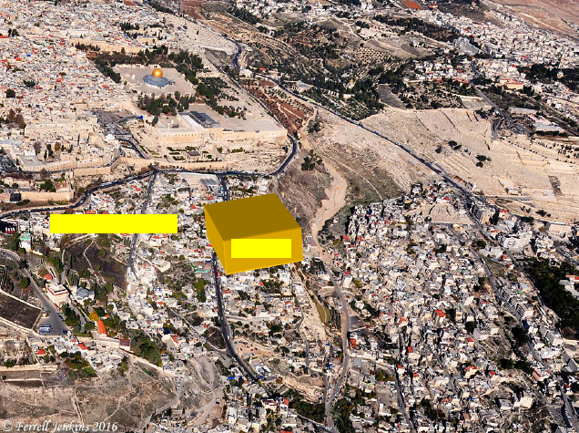
Figure 1. The Temple Was in the Valley and Fort Antonia on a Promontory
|
|
Fig. 1. The approximate location of the temple is superimposed on this aerial photo, showing, with some distortion of angle and perspective, how it was “within the valley,” whereas the alleged temple mount is on a promontory above the valley, which is how Josephus described Fort Antonia. The large rock of Fort Antonia described by Josephus is under the Dome of the Rock. [Courtesy of Ferrell Jenkins -- https://ferrelljenkins.wordpress.com/tag/city-of-david/]
Plans of Titus to Attack the City and the Temple
When Titus arrived in Jerusalem, he encamped at Mount Scopus [north of the Mount of Olives, DWS] and rode his horse around the city to ascertain the strength of its walls. His survey duplicates Josephus’s account of Pompey previously doing the same thing and contains a description of the temple’s situation: “the valley before the walls was terrible; and…the temple, which was within that valley, was itself encompassed [surrounded] with a very strong wall” (War I, 7, 141). As can be seen in Fig. 1, the traditional temple mount is not located “within” a valley, but on a promontory containing a large rock at its approximate center, both descriptions of the tower of Antonia (War V, 5, 238). In addition, there is no source that describes a large squarish rock as a feature of the temple mount.
After his survey, Titus initially decided to take the upper city (on the western hill) through the Third Wall and the temple through Fort Antonia (War V, 6, 260). Josephus had special designations for the First, Second, and Third Walls, so interpretive care must be taken when the walls are mentioned, because the order of their conquest went: Third, Second, First. Josephus mentions the Third Wall:
“It was [Herod] Agrippa who encompassed [surrounded] the parts added to the old city with this wall.…and those parts of it that stood northward of the temple, and joined that hill to the city, made it considerably larger, and occasioned that hill, which was in number the fourth, and is called ‘Bezetha,’ to be inhabited also. It lies near to the tower of Antonia, but is divided from it by a deep valley which was dug on purpose, and that in order to hinder the foundations of the tower of Antonia from joining to this hill, and thereby affording the opportunity of getting to it with ease.…” (War V, 2, 148–150).
In the foregoing passage, Josephus explains that it was the parts northward of the temple which joined to the hill Bezetha; they were not joined to the temple itself. By “parts,” he means the tower of Antonia, which had a natural deep valley (made deeper by men) separating it from Bezetha as part of its protection. The natural valley is mistakenly attributed to the alleged temple mount in “Jerusalem, The Temple Mount and Its Environs,” in The New Encyclopedia of Archaeological Excavations in the Holy Land (1993):
“The northeastern corner of the enclosure [of the alleged temple mount] was built over the course of the Bezetha Valley extending the temple mount area to its northern bank.…In the north of the eastern wall, where it crosses the Bezetha Valley, the original masonry survives to a maximum height of some 40 m. The northeastern corner itself has survived to a maximum height of about 7 m above the present level of the temple mount” (“Jerusalem,” The New Encyclopedia, pp. 737–738).
Figure 2. Warren’s Bedrock Levels with the Alleged Temple Mount Superimposed
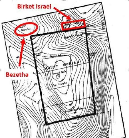 |
Fig. 2. The map indicates Bezetha (the New City) on the north of Jerusalem, which Josephus described as being separated from Antonia by a deep valley. The map shows the Kidron Valley curving toward the northwest. Josephus called this natural valley the Bezetha Valley. Note there is no such valley north of the scarp claimed for the traditionalists’ Antonia (only rising bedrock levels are pictured); hence, it does not match the configuration of Bezetha, the deep manmade valley, and Fort Antonia, described by Josephus. But if we identify the alleged temple mount as Antonia, the Birket Israel, a large manmade pool dug within the natural valley on the northeast, easily becomes identifiable with the Struthion Pool, through which Titus attacked Fort Antonia. Herod’s temple did not have a large manmade pool flush against its north side.
Josephus indicates that instead of joining Bezetha on the north, the temple linked to a 600+-foot plaza on its north side, above which two 600-foot aerial bridges joined the roofs of the temple’s porticoes to the tower of Antonia. Benjamin Mazar excavated part of the plaza (now called the Ophel, based on tradition) for the length of the alleged temple mount’s south wall and 300 feet to the south. Combined with Josephus’s description of the temple as a six-furlong area (Antiquities V, 5, 192), we can reason the south wall of Antonia was at least a furlong in length. (The six-furlong size is created by adding the area under the two 600-foot aerial bridges to the four-furlong perimeter of the temple mount).
However, the current models of Fort Antonia confine it to a leveled rock scarp northwest of the alleged temple mount, its south perimeter measuring only 394 feet long and its width 147 feet (see Fig. 3). Hence, the current models of Fort Antonia do not provide for the deduced length of its south wall according to Josephus’s description of a six-furlong area. [7]
Figure 3. The Traditionalist Model of the Temple and Fort Antonia
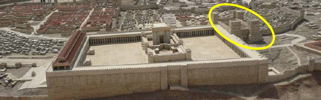 |
Fig. 3. Because tradition identifies Antonia as the Jerusalem Temple Mount, scholars are forced to imagine the former as a small castle at its northwest corner, as shown in this model. However, this model (1) resembles no other Roman camp in the Greco-Roman world, (2) does not “dominate the temple,” (3) has no 600-foot aerial bridges connecting it to the temple, (4) does not provide for “broad spaces for camps,” and (5) is not the size of “several cities,” as described by Josephus. But the alleged temple mount does fit these descriptions, minus the aerial bridges, which were destroyed in the siege. Eleazar reported that after the 70 AD destruction, the temple mount had been dug up by its foundations, while the Roman camp was the only monument remaining, as happens to be the case of the alleged “temple mount.” [Photo cropped by Chezdovi from the original by Thomazzo, Wikimedia].
Figure 4. Ernest L. Martin’s Model of the Temple and Fort Antonia
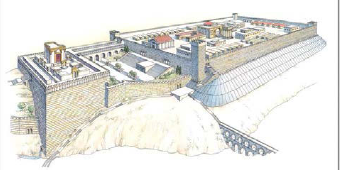 |
Fig. 4. The model shows it was
Fort Antonia (the alleged temple mount) that joined to Bezetha, the New City to
the north, not the temple mount, which was in the City of David. (Courtesy of
David Sielaff, ASK Publications)
Figure 5. Alterations to Martin’s Version
 |
Fig. 5. My rough redrawing of Martin’s version shows the two aerial bridges at both the west and east ends of the temple, forming a six-furlong area, as Josephus described. I have also redrawn the temple’s situation, to show the northeastern corner was also in the valley.
Fig. 6 below [on page 9] is a flawed map of Second Temple Jerusalem, based on the mis-identification of the temple mount, which nevertheless reasonably uses the Sukenik-Mayer wall line for the Third Wall surrounding the New City. The line of the Second Wall is based on Josephus’s statement that:
“… the second wall took its beginning from that gate which they called ‘Gennath,’ which belonged to the first wall; it only encompassed the northern quarter of the city, and reached as far as the tower of Antonia” (War V, 4, 146). [8]
The Fig. 6 map shows Antonia as a tiny edifice on the northwest of the alleged temple mount, even though Josephus said it was the size of “several cities” (War V, 5, 241). In addition, Tacitus said the walls of Fort Antonia lay beneath Herod’s palace (Histories V, 11), but the map shows the traditionalist model of Fort Antonia is too far north to match this description. The Second Wall did not join to the rock scarp imagined for the traditionalist’s Fort Antonia on this map, but it joined the alleged temple mount at some location near it on the north or west.
The Siege Begins
Titus began the attack on the Third Wall at the Monument of John [Hyrcanus, a former high priest, DWS], because there the “first fortification was lower, and the second was not joined to it” (War V, 6, 259– 260). This location on Fig. 6 would be somewhere along the wall north of the Hippicus tower. Once inside, the Romans took possession of the Third Wall and demolished a great part of what Josephus described as a massively constructed fortification. The thinly populated area was probably mostly abandoned before the Romans took possession (War V, 7, 302).
Titus then moved his camp inside the walls to the place called “The Camp of the Assyrians” and “seized on everything as far as Cedron [Kidron]” (War V, 7, 303). He fortified the spot of ground near John’s monument “as far as the gate where water was brought in to the tower Hippicus” (near or at the contemporary Jaffa Gate) (War V, 7, 304).
Five days after taking the Third
Wall, Titus made a narrow breach in the Second Wall near “where were the
merchants of wool, the braziers, and the market for cloth, and where the narrow
streets led obliquely to the wall” (War V, 8, 331), presumably at the “middle
tower of the north part of the wall” (War V, 7, 317).
There followed a battle where the Jews had an advantage “by their full knowledge
of those narrow lanes” and were able to drive the Romans out and even sally out
of the “upper gates” to assault the Romans who guarded the wall (War
V, 8, 336). Four days later, however, Titus took possession of the wall again
and…
“demolished it entirely. And when he had put a garrison into the towers that were on the south parts of the city, he contrived how he might assault the third wall [meaning the First Wall, but the third to be conquered]” (War V, 8, 347).
Josephus does not speak of Titus demolishing the area within the Second Wall immediately after its conquest, but says the people fled when “they could no longer support themselves against the vehement assaults of Titus” (War V, 8, 346).
The garrisoning of towers “on the south parts of the city” raises the question as to what Josephus meant. From the Fig. 6 map, the towers on the south parts of the New City (Bezetha), including the part within the proposed Second Wall, would have been those of the alleged temple mount or the First Wall, on the north of the upper city on the western hill. But Titus could not have put a garrison in these towers, because they were in the possession of the Jews. He must have been referring to towers on the south parts of the lower city (as designated on the Fig. 6 map), as the First Wall surrounded both the western hill and the Acra, south of the temple.
The First Wall
Since traditionalists misplaced part of the First Wall, according to the false identification of the alleged temple mount, a review of Josephus’s account of the line of the First Wall in War V, 4, 144 is in order:
“Now, that wall began on the north, at the tower called ‘Hippicus,’ and extended as far as the ‘Xistus,’ a place so called, and then, joining to the council-house, ended at the west passage of the temple.
"But if we go the other way westward, it began at the same place, and extended through a place called ‘Bethso,’ to the gate of the Essenes: and after that it went southward, having its bending above the fountain Siloam, where it also bends again towards the east at Solomon’s pool and reaches as far as a certain place which they called ‘Ophlas,’ where it joined to the eastern passage of the temple.”
The Fig. 6 map below shows the First Wall joining with Wilson’s Arch on the west of the alleged temple mount. However, Josephus described the Xistus as being below the temple’s west passage where “the city lay near to the temple in the manner of a theater” (Antiquities XV, 11, 410), that is, the lower Tyropoeon Valley. [9] Hence, the First Wall could not have joined where the traditionalists place it.
Unfortunately, Josephus does not mention that the First Wall either curved around or made a right angle on the western hill, proceeding south, in order to enclose it, and when it reached near to the Xystus, a branch of it crossed over the lower Tyropoeon Valley to reach the council house, which joined to the western wall of the temple.
Josephus also does not describe the wall continuing south to join with the track of the First Wall skirting the south on its way to the mouth of the lower Tyropoeon Valley. And, even though Fig. 6 does not show any such track for the First Wall (based on the temple mount tradition), leaving the western hill entirely without a wall on its east side, the fact that it was walled is evidenced from Titus’s attack plan to take it, which will be described later on.
Figure 6. Map of Second Temple Jerusalem During the Siege of Titus
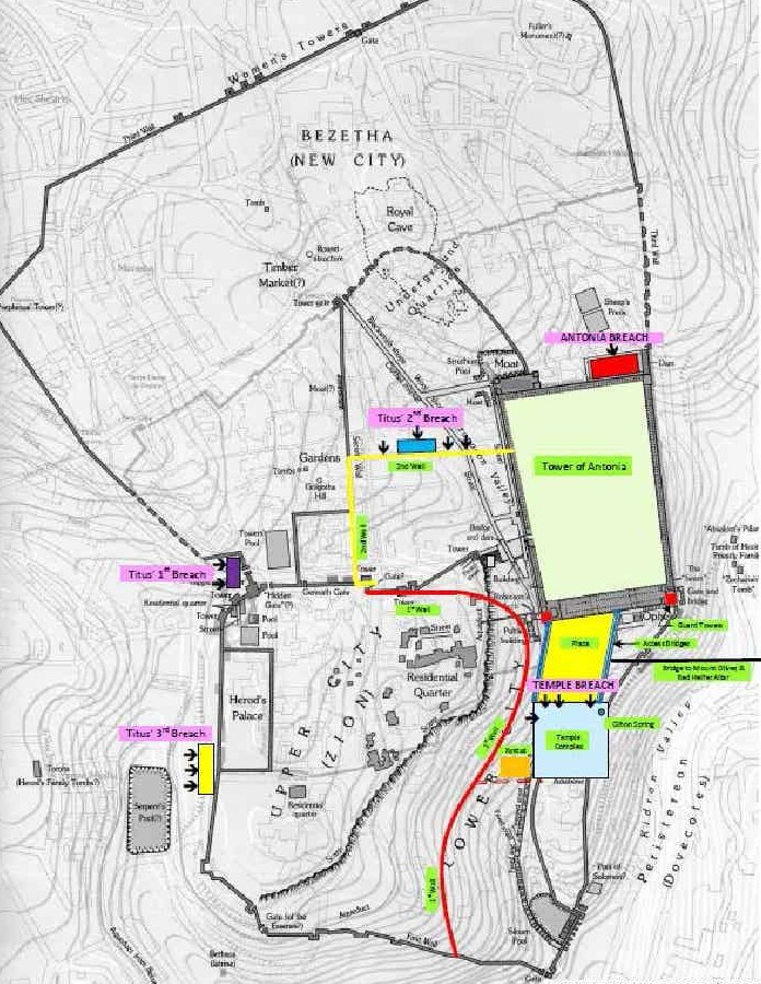 |
Fig. 6. The map shows the correct line of the Third Wall, but guesses at the line of the Second Wall. Because of the traditionalists' erroneous identification of the alleged temple mount, it does not show any wall between the upper and lower cities, contrary to Josephus’s description that the First Wall joined the Xystus. A guess as to how the actual wall was placed has been added to the map, including indications of where the two banks Titus raised against the wall were situated. One was located in the lower Tyropoeon Valley where the First Wall crossed over to meet the temple. The other was on the west side of the western hill, where the Romans engineered the final breach. The “Struthion Pool” identified on the map was discredited after being dated to Hadrian’s era. (Map from The New International Encyclopedia of Archaeological Excavations in the Holy Land [1993], p. 718).
The Scope of the Second Wall’s Enclosure
Even if we correctly identify the alleged temple mount as Fort Antonia, the problem of what the demolished Second Wall had formerly enclosed persists. From archaeological excavations along the entire western wall of the alleged temple mount and further south, it is clear that two of the Antonia gates led onto a paved promenade, which appears to have been uninterrupted in its descent to the gate at the mouth of the lower Tyropoeon Valley.
This suggests the wall that crossed the lower Tyropoeon Valley to reach the temple’s west passage did not impede the pedestrians’ progress, or that they passed through a gate which has disappeared. There is also the possibility that this wall, when it turned to cross over the valley, was the lower part of the aerial bridge above the Xistus, built by the Hasmoneans, destroyed by Pompey, and rebuilt.
Figure 7. Ernest L. Marin’s
Birdseye View of the Temple and Fort Antonia
 |
Fig. 7. I have added a white box in the location of the Birket Israel, at the northeast end of Fort Antonia, because this was the location of the Struthion Pool. (Courtesy of David Sielaff, ASK Publications)
All this implies a possibility that the Second Wall did not have a southern border across the upper Tyropoeon Valley. Were this the case, when Titus demolished the Second Wall he would have gained access to the plaza between Fort Antonia and the Temple and the lower Tyropoeon Valley. Why, then, would he go to the trouble to break down Fort Antonia’s north wall (in the alleged temple mount) in order to take the temple (the actual temple), when its north wall was vulnerable as soon as he conquered the Second Wall? Three possibilities include:
(1) To bring his armies from the upper Tyropoeon to the plaza would mean passing within close range of the First Wall and Antonia, especially near the staircase at Robinson’s Arch, in order to reach the plaza. Much loss could occur to his soldiers, so Titus regularly encamped and maneuvered them according to their maximum safety.
(2) Without possession of the two bridges, his soldiers would be hard pressed to raise banks against the temple without further loss of life from the Jews on Antonia’s south wall, on the bridges, and on the temple’s north wall.
(3) Possession of Antonia was a strategic necessity for maintaining control of the northern boundaries of the damaged city, overseeing both the upper city and the temple, and providing protection for his soldiers camped in the New City.
After taking possession of the Second Wall, Titus had his soldiers array themselves in an ordered, fulldress exhibition to receive their pay and encourage the Jews trapped on the western hill to surrender. Josephus said, “the whole old wall and the north side of the temple were full of spectators” (War V, 9, 352). The exhibition probably took place at the Camp of the Assyrians, at a distance (about 1300 feet) north of the “old wall” (the First Wall) and the same distance from Fort Antonia, since that area would be the safest for such a display and in view of his target audience (the Jews enclosed on the western hill).
The point is brought up because a glance at the Fig. 6 map above shows people at the north wall of the alleged temple mount would not be able to see the exhibition, as the rock scarp and the traditionalists’ Antonia would block the view along the masonry wall. (The north wall is part rock scarp and part masonry). However, from the temple’s very high position on the southeastern hill, they would be able to see the event.
Figure 8. The Traditionalists’ Antonia and Struthion Pool
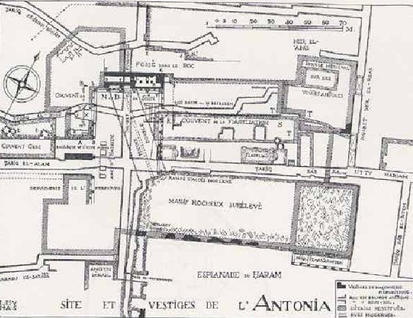 |
Fig. 8. The Struthion Pool of the traditionalists (Piscine Double -- Twin Pool with dotted lines) is flush against the angle of the “Massif Rocheux Sureleve” (the leveled rock scarp). However, Josephus describes the site of the breach at the north wall as a masonry wall where soldiers removed several rocks from the foundation. In addition, since the site of the breach was also where a “ready and broad way” was made for Titus’s armies to enter Fort Antonia, the rock scarp does not fit the descriptions of Josephus’s Antonia. Notice the “Esplanade du Haram” would have been available for a direct attack further east. (Map from Vincent and Abel, 1914)
The Siege of Fort Antonia
When Titus set about to take possession of Antonia, he had conquered the entire New City and everything within the First and Second Walls. Hence, he chose to set up two banks on Antonia’s northern wall (War V, 12, 523). One was near to the middle of the Struthius Pool and the other 20 cubits away (War V, 11, 467). If this information is applied to the traditionalists’ Struthius Pool, which is only 46 feet wide, one can see from Fig. 8 that both banks would have been mounted against the elevated rock scarp (massif rocheux sureleve) which is the traditionalist Fort Antonia.
Approximately 650 feet along the alleged temple mount’s north wall would have been available for direct attack, especially along the inner wall of the Birket Israel. However, if we identify the alleged temple mount as actually being Fort Antonia and the 360 x 126 foot Birket Israel as the Struthion Pool, both banks would have been within the pool. This pool is indicated by the white box on the Fig. 7 map, at the northeast corner of the alleged temple mount.
During Titus’s building of the banks, John secretly undermined the floor of the Struthius Pool with beams, interlaced with pitch and bitumen, taking care to make it seem solid. He then set it on fire and the Roman siege engines came crashing down (War V, 11, 469–470). This, however, served to motivate the Romans, as implied in War VI, 1, 25:
“Now these Romans struggled hard to bring them [the siege engines], as deeming that this zeal of the Jews was in order to avoid any impression to be made on the tower of Antonia, because its wall was but weak, and its foundations rotten.”
The Romans persevered and with great pains were able to dislodge four of the foundation stones in the place where the wall had been undermined, which eventually led to its collapse (War VI, 1, 27). However, the foundations of the traditionalist Antonia are not “weak” or “rotten,” but consist of solid rock; hence, the description by Josephus of a masonry wall cannot be reasonably applied. However, his descriptions can be applied to the Birket Israel at the northwest corner of the alleged temple mount, where the Bezetha Valley is underneath and the wall there has the fewest Herodian stones of any of its walls, attesting that a great deal of damage formerly occurred at this site (see Martin, 2000).
In addition to this conundrum for the traditionalists, one must look at the map and ask why Titus would want to attack the “temple” through Fort Antonia? The Fig. 6 map shows that according to the traditionalist configuration, there were about 650 feet along the “temple mount’s” north wall which could have been directly accessed, including the wall within the Birket Israel.
The Siege of the Temple from Fort Antonia
Once the Roman soldiers had climbed onto Fort Antonia’s platform, after a brief clash and demolishing a second wall, they pursued the Jews who were “flying away” to the temple. Josephus said a “terrible battle” was fought at the “entrance of the temple” (War VI, 1, 71, 74), which he locates at its northwest corner (War V, 5, 238), where the western 600-foot aerial bridge connected Fort Antonia to the temple’s northwest corner (War VI, 2, 144). But where would this battle take place in the alleged temple mount models that do not include this 600-foot long aerial passage?
The traditionalists have adopted two models of the temple’s outer perimeter. In the first model, Fort Antonia is flush against the perimeter of the temple’s outer courts, which requires ignoring the measurements for them in the sources, in favor of the very much larger measurements of the alleged temple mount (920 by 1596 by 1040 by 1556 feet as opposed to 600 or 750 feet square).
In this model, entrance from Antonia
to the temple would have to be onto the roofs of the porticoes (if there were
any in this era), which would be a “narrow space,” as described by Josephus (War
VI, 2, 144, Loeb translation), or via a stairway descending from Antonia’s south
wall onto the temple’s northern courts, which would not be a “narrow space.” But
this scenario would place the battles inside the temple mount’s outer courts,
whereas Josephus says the battles were fought at the entrance to the temple, not
within the temple.
The second model of the traditionalists claims that the outer perimeter of the
temple courts was within the alleged temple mount, usually indicated by a line
drawing matching the actual proportions of the temple given in the sources (as
in Fig. 6). However, this line drawing option moves the outer courts to within
the temple mount and requires the conquest of
(1) an imagined north wall of Antonia,
(2) the north wall of the alleged temple mount,
(3) the walls of the imagined outer court within the alleged temple mount, and
(4) the walls of the imagined inner court, creating a siege model incompatible with the descriptions of Josephus.
In addition, the scenario creates the same circumstance of having the earliest battles take place on the courts of the alleged temple mount platform, when the siege was still taking place in the “narrow space” at the entrance.
Figure 9. Banks Set Up by Titus at the Temple’s North Wall in the City of David
 |
Fig. 9. The asterisks (*) in this figure show where the banks would have been set up against the temple’s walls, three on the north wall and one on the west. In this version, Titus’s plan has logic and Josephus’ narrative makes sense.
The problem for the “temple mount” traditionalist models continues in the same vein when Titus orders “a ready and broad way” (War VI, 2, 149) made at the breach in Antonia’s north wall, where his army could enter en masse. Since the escarpment on which the alleged Antonia supposedly stood does not match the masonry north wall described by Josephus, it could not be breached or expanded to a “ready and broad way.”
However, at the actual location, once having obtained the alleged temple mount, “the legions” (perhaps all four legions: V Macedonia, XII Fulminata, X Fretensis, XV Apollinaris) could pass through Antonia, descend to the southern plaza, and start to build banks at the temple’s north wall. War VI, 2, 149 describes these banks as being (1) near to the northwest corner of the inner temple, (2) another at the northern edifice between the two gates, (3) one at the western passage of the outer court of the temple, and (4) one against the northern passage. Fig. 9 shows where these banks would have been mounted and their proximity to the inner courts of the temple.
The application of Josephus’s description to the City of David model is straightforward and logical. However, when applied to the traditionalist models, Titus falls into the role of a military moron. Taking the Fig. 3 model for our guide (it being the trapezoidal outer perimeter choice), building the first bank opposite the northwest corner of the temple’s inner precincts would have required exiting the alleged Fort Antonia in order to be in position against the “temple’s” west wall. To build the other three banks, the same exit from Antonia would be required in order for Titus to access the “temple’s” north wall, which he obviously should have done in the first place. How crazy can he be?
However, if we take the outer-perimeter-as-line-drawing choice, as in Fig. 6, the same problem exists. He could move his troops from the alleged Fort Antonia onto the 36-acre platform and then raise banks against the “temple’s” outer perimeter, but why conquer Fort Antonia first, when, again, he could directly attack the alleged temple mount platform?
The conquest of the temple began when the Romans first breached the temple’s outer wall on the west side, showing they already possessed the lower Tyropoeon Valley, since they were successfully able to build a bank there. After a frenzied defense by the Jews inside the temple, the Romans took possession of the outer courts, then the inner courts, then the sanctuary. When all had been set on fire within the temple, the people who had been forced to remain within its precincts poured out of its south gates onto the square of the Acra and into the residential area further south (War VI, 7, 366).
Titus’s Final Orders
In War VI, 6, 316, Josephus remarks on the flight of the rebellious into the city upon the burning of the sanctuary. In this instance, the “city” includes the upper city, because upon the entreaty of the tyrants, Simon and John, Titus decided to address them and
“…placed himself on the western side of the outer temple; for there were gates on that side above the Xystus, and a bridge that connected the upper city to the temple. This bridge it was that lay between the tyrants and Caesar, and parted them” (War VI, 6, 324–325).
The Xystus stood in the lower Tyropoeon Valley below these western temple gates, where the “city” [the upper city on the western hill] “lay near to the temple in the manner of a theater” (Antiquities XV, 11, 410). The traditionalists identify the bridge near the Xystus as the one supported by Wilson’s Arch. [10] However, the city opposite lies in a straight line, not “in the manner of a theater,” and there are conflicting dates regarding the bridge’s origin (it being attached to the western wall, which was an extension of the Baris in the Hasmonean era).
Upon Titus’s offer to save the people if they would surrender, the tyrants attempted to negotiate the terms, which so incensed Titus that he gave orders to “both burn and plunder the city” (War VI, 6, 353), meaning the lower city (according to Fig. 6) and the Acra (the lower city on the southeastern hill), which were in his possession. The former area contained the repository of the archives and the council house. The soldiers also burned Ophlas. The fire then proceeded
“…as far as the palace of Queen Helena, which was in the middle of Acra; the lanes also were burned down, as were the houses full of the dead bodies of such as were destroyed by the famine” (War VI, 6, 354–355).
On the same day, “the sons and
brothers of Izates the king, together with many others of the eminent men of the
populace” (War VI, 6, 356) came to beg of Titus his oath of
security, upon which they were taken as hostages to Rome. The fire caused the
“rebellious” to rush into the “royal palace” in the Acra area.
They found in this unidentified palace two Roman soldiers, one of whom they
killed, and the other they took to Simon. But the next day, “the Romans drove
the robbers out of the lower city and set all on fire as far as Siloam” (War
VI, 7, 363). Hence, Josephus witnessed the second demise of the City of David.
Titus then turned his attention toward the western hill. The Fig. 6 map shows the western hill without a wall on its east side, because Josephus’s description of the First Wall’s ending at the temple’s western wall is mistakenly applied to the alleged temple mount (the line you see is for the lower aqueduct). If there had been no wall, then there would have been no need for Titus to order the raising of banks on the western side of the western hill near Herod’s palace and one at the Xystus (War VI, 8, 377).
He already had in his possession the temple, the Ophel, the City of David and the lower city (the names according to the map) and could simply lead his troops up the “unwalled” east side of the western hill from any of these areas. Hence, the misidentification of Fort Antonia as the temple mount causes the First Wall to disappear from the east side of the western hill and casts Titus, once again, in the role of military moron, wasting his resources and his troops’ time and energy on banks aimed at an unfortified area. The western hill was conquered through the breach made at the western bank (War VI, 8, 397).
Conclusion
The Siege of Titus, set in the context of Josephus’s extensive descriptions regarding Fort Antonia, the temple, and Jerusalem topographical indicators, serves to discredit the Jerusalem Temple Mount tradition and rightly identifies today’s alleged temple mount as Fort Antonia, the same monument which Eleazar of Masada declared as “the only monument remaining” after the siege (War VII, 8, 376). Unfortunately, however, traditionalists continue to claim legitimacy for their imaginary models of the temple and Fort Antonia, though bereft of any support from archaeological findings or historical sources.
Footnotes:
[1] Her second book shows the impossibility of the so-called “Temple Mount” and demonstrates the necessity of a Gihon site of the Temples. She has developed unique data from her own research beyond Dr. Martin’s own comprehensive work. This is an excellent example of how proper scholarship advances to become accepted truth in conformity with Scripture and history. DWS
[2] To understand the background of its actual identity as the tower of Antonia, readers should refer to two previous papers on Ms. Sams’ website: The Temple Mount in the City of David: Ancient Authenticating Descriptions and The Two 600-Foot Aerial Bridges Connecting the Temple in the City of David to Fort Antonia (the Alleged Temple Mount). The first paper contains descriptions placing the temple in the center of the southeastern hill over the Gihon Spring. The second paper analyzes the descriptions by Josephus of two aerial access connections between Antonia and the temple porticoes. DWS
[3] The passage describing the hills of Jerusalem is from War V, 4, 137–139:
“But the other hill [the southeastern hill], which was called “Acra” and sustains the lower city, is of the shape of a moon when she is horned. Near to there was a third hill, but naturally lower than Acra, and parted formerly from the other by a broad valley. However, in those times when the Asamoneans reigned, they filled up that valley with earth, and had a mind to join the city to the temple. They then took off part of the height of Acra, and reduced it to be of less elevation than it was before, that the temple might be superior to it.”
The passage is confusing because the translation describes the whole southeastern hill (“the shape of the moon when she is horned”) as Acra and refers to it as the lower city. Then it describes Mount Zion, or the hill on which the temple stood, as “naturally lower than Acra,” this time referring to Acra as the hill on which the citadel stood (not the whole southeastern hill).
This hill was south of Mount Zion and was leveled to bedrock, along with the citadel, by Simon the Hasmonean. To clarify, the southeastern hill apparently had two occupational tells on its ridge, built up from centuries of habitation. The one above the Spring, later named Mount Zion, was lower than the one south of it, where the citadel stood, overlooking it (Antiquities XII, 5, 252). A valley between them was filled when Solomon built the temple (War V, 5, 189). The hill on which the Akra stood was razed by Simon the Hasmonean, and then Mount Zion, on which the temple was built, became the only hill and was hence “superior” (Antiquities XIII, 6, 215–217; War V, 4, 139).
However, no part of the southeastern hill has ever been superior to the 2,440 foot elevation at the Dome of the Rock on the hill claimed by traditionalists as Mount Moriah. Hence, Josephus’s description for the demise of the hill on which the citadel stood and the temple’s subsequent superiority in height does not make sense when applied to the traditional location of the temple. MS
[4] Cahill and Tarler (1994) in Excavations directed by Yigal Shiloh at the City of David, 1978–1985 in H. Geva, (Ed.), Ancient Jerusalem Revealed (Jerusalem: Israel Exploration Society) have said (p. 41):
“The well-stratified deposits of the Persian period discovered in the City of David stand in sharp contrast to the lack of comparable remains from other excavated areas of Jerusalem. This suggests the City of David was the city’s main center of occupation during this period.”
These authors say the same for the Hellenistic and early Hasmonean periods (p. 42). MS
[5] Passages which refer to the Seleucid Acra in the City of David are Antiquities XII, 3, 133; Antiquities XII, 5, 252; Antiquities XII, 7, 317–318; Antiquities XIII, 5, 181–182; 1 Maccabees 13: 49–50, 52; Antiquities XIII, 6, 215–216. MS
[6] Sources showing the temple stood in the Kidron Valley are: Antiquities XV, 11, 398; War I, 7, 141; War VI, 3, 192; Josippon Ben Gorion, p. 62; Nehemiah 3:27. MS
[7] Regarding the typical size of Roman camps, Edward Dabrowa compiled a list of early 1st and 2nd century camps from around the world. I have added to his list the traditionalists’ Antonia. It is uncertain which legions camped at Antonia when it was taken.
XIII Gemina at Apulum – 54 acres
IV Flavia at Sarmizegetusa – 81 acres
II Adriatrix (first camp) at Aquineum – 49 acres
IV Flavia at Singidunum – 46 acres
XV Apollinaris at Carnumtum – 41 acres
VII Claudia at Viminacium – 41 acres
X Gemina at Carnumtum – 45 acres
III Cyrenica at Bostra – 41 acres
XI Claudia at Durostorum – 53 acres
XVI Flavia Firma at Satala – 41 acres
Traditional Fort Antonia at Jerusalem – 5 acres
(The alleged temple mount at Jerusalem - 36 acres)
In addition, M. Avi-Yonah, in his article “The Third and Second Walls” (in Israel Exploration Journal, Vol. 18 (2), retrieved from the JSTOR website: http://www.jstor.org/stable/27925133.) refers to Kenyon’s rejection of the Third Wall as a Tenth Legion wall, since a Roman legionary camp “was of a stereotyped rectangular plan” -- similar to the 36-acre alleged temple mount. MS
[8] Three archaeological sites which have been used to recreate the line of this wall: (1) Nahman Avigad’s excavation in the Jewish Quarter, which yielded remains of a wall and two gates, (2) The gate found under the present Damascus Gate, with a possible Herodian dating, and (3) Remains from R.W. Hamilton’s sounding C, indicating the presence of an early wall ascending east up the hill from the Damascus Gate. MS
[9] That the bridge crossing over from the upper city to the temple was located in the lower Tyropoeon is affirmed by the description of the Venerable Bede in De Locis Sanctis, which says: “And in the lower part of the city, where the Temple, located in the vicinity of the wall from the east, had been connected to the city itself by an access bridge crossing over the middle…” The east wall of the city referred to was that built by Eudocia on the southeastern hill. MS
[10] The dating of Wilson’s Arch is disputed, with the following possibilities given:
• Mazar (1975) dated the arch to the Hasmonean period, with a proposed reconstruction by Herod.
• The New Encyclopedia of Archaeological Excavations in the Holy Land (1993) says: “Warren & Conder argued it was possible the three lower courses of the Arch, as well as the pier on the other side, were built in the second temple period….” (p. 742).
• Geva (1994) said the dating was uncertain and still an undecided issue, but added an Early Arab dating by certain scholars and mentioned “the recent discovery of a Roman-Byzantine street pavement above the complex of vaults extending west-ward from Wilson’s Arch might testify to the earlier (second temple) dating” (p. 15).
• Bahat (1995, Nov/Dec) supervised the Western Wall site and uncovered evidence indicating Wilson’s Arch was not of Herodian date, but constructed during the 7th or 8th century AD. However, in his book Touching the Stones of Our Heritage, Bahat (2000) effectively reverses this dating when he states “there was a gate at this site in the Second Temple period. The gate of that period stood at the eastern end of the Great Bridge, connecting the Temple Mount with the upper city” (p. 62). MS
References:
Avi-Yonah, M. (1968). “The Third and Second Walls of Jerusalem” in Israel Exploration Journal, Vol. 18(2), pp. 98– 125, retrieved from the JSTOR website: http://www.jstor.org/stable/27925133.
Bahat, D. (1995, Nov/Dec). “Jerusalem down under: Tunneling along Herod’s Temple Mount Wall.” Biblical Archaeology Review, 21(6), 30–47.
Bahat, D. (2002). Touching the stones of our heritage. Jerusalem: The Western Wall Heritage Foundation.
Cahill, J. M., & Tarler, D. (1994). Excavations directed by Yigal Shiloh at the City of David, 1978–1985 in H. Geva, (Ed.), Ancient Jerusalem Revealed. (pp. 3l–45). Jerusalem: Israel Exploration Society.
Dabrowa, E. (2015). The “Camp of the Assyrians” and the Third Wall of Jerusalem. Scripta Judaica Cracoviensia, Vol. 13, retrieved from Academia.edu. website: https://www.academia.edu/23948664/The_Camp_of_the_Assyrians_and_the_Third_Wall _of_Jerusalem
Geva, H. (1994). Twenty five years of excavations in Jerusalem, 1967–1992: Achievements and Evaluation, in H. Geva (Ed.). Ancient Jerusalem Revealed. Jerusalem: Israel Exploration Society.
“Jerusalem, The Temple Mount and Its Environs,” in The New Encyclopedia of Archaeological Excavations in the Holy Land. (1993). E. Stern (Ed.), Jerusalem: Carta.
Josephus. F. (1999). The
New Complete Works of Josephus (W. Whiston, Trans.). Grand Rapids, MI:
Kregel Publications.
Josippon ben Gorion. (c. 9th or 10th century AD/1684 AD). The Wonderful,
and Most Deplorable History of the Latter Times of the Jews: with the
Destruction of the City of Jerusalem (Trans. James Howell). London:
Printed for William Thackeray in Duck-lane. Presented by Early English Books
Online.
Martin, E. L. (2000). The Temples that Jerusalem Forgot. Portland, OR: ASK Publications. http://www.askelm.com/TempBook/index.asp
Mazar, B. (1975). The Mountain of the Lord. Garden City, NY: Doubleday & Company.
Sams. M. (n.d.). A Proposal for the Configuration of Solomon’s Temple Mount. Academia.edu website: https://www.academia.edu/35235638/A_Proposal_ for_the_Configuration_of _Solomons_Temple
Sams, M. (2015). The Jerusalem Temple Mount Myth. (n.p.). Marilyn Sams http://jerusalemtemplemountmyth.com/
Sams, M. (2017). The Jerusalem Temple Mount: A Compendium of Ancient Descriptions. (n.p.). Marilyn Sams https://www.smashwords.com/books/view/747513
Sams, M. (2014). The Byzantine Presence on the Temple Mount. Academia.edu website: https://www.academia.edu/11818163/The_Byzantine_Presence_on_the_Temple_Mount
The Venerable Bede. (n.d./2001). De Locis Sanctis. (Trans. A. vander Nat). Retrieved July 8, 2013, from Loyola University Chicago website: http://avande1.sites.luc.edu/jerusalem/sources/bede.htm.
|
Hope of Israel Ministries -- Preaching YEHOVAH's Truth Without Fear or Favor! |
|
Hope of
Israel Ministries |
 |
Scan with your Smartphone for more information |