 |
Newly Discovered -- The First River of Eden!
|
Boston University scientist Farouk El-Baz had long wondered about the pebbles of granite and basalt that are abundant throughout Kuwait. The problem was that these pebbles are not indigenous to the area. The nearest source for these rocks lies in the Hijaz Mountains -- 650 miles to the west in Saudi Arabia! How did the pebbles reach Kuwait? |
by John D. Keyser
While most people worry little about pebbles unless they are in their shoes, to geologists pebbles provide important, easily attained clues to an area's geologic composition and history. The pebbles of Kuwait offered Boston University scientist Farouk El-Baz his first humble clue to detecting a mighty river that once flowed across the now-desiccated Arabian Peninsula. Examining photos of the region taken by earth-orbiting satellites, El-Baz came to the startling conclusion that he had discovered one of the rivers of Eden -- the fabled Pishon River of Genesis 2 -- long thought to have been lost to mankind as a result of the destructive action of Noah's flood and the eroding winds of a vastly altered weather system. This article relates the fascinating details!
In Genesis 2:10-14 we read:
"Now a river went out of Eden to water the garden, and from there it parted and became FOUR RIVERHEADS. The name of the first is PISHON; it is the one which encompasses the whole land of HAVILAH, where there is gold. And the gold of that land is good. Bdellium and the onyx stone are there. The name of the second river is GIHON; it is the one which encompasses the whole land of Cush. The name of the third river is HIDDEKEL [TIGRIS]; it is the one which goes toward the east of Assyria. The fourth river is the EUPHRATES."
While two of the four rivers mentioned in this passage are recognizable today and flow in the same general location as they did before the Flood, the other two have apparently disappeared from the face of the earth.
|
Great changes occurred in the topography of the earth during the Noachian flood and also at other times in the earth's history since; so it is not that remarkable that some of the pre-Flood geographical features changed or disappeared altogether. As an example of this, scientists have found evidence of floods in Mesopotamia, deep lakes in Africa, grasslands and lakes in Arabia and heavy forest cover along the eastern Mediterranean coast. This provides testimony that a lengthy wet period once enveloped the ancient Near East.
Some researchers, such as Ernest L. Martin, claim that the Karun River (which flows into the Euphrates/Tigris river system) is the Pishon, while the Karkheh, which also flows into the Euphrates/Tigris river system, is the Gihon. However, these two rivers are minor in nature and do not fulfill the requirements of the Book of Genesis.
In an attempt to correctly locate and identify the Pishon and the Gihon rivers, we need to closely evaluate Genesis chapter 2.
Garden in Armenia?
Since the Tigris and the Euphrates have their sources in the mountainous region of Armenia, it is usually assumed by theologians today that the Garden of Eden was located in that same area. Therefore, they claim, the Gihon could be the Araxes which flows into the Caspian Sea and the Pishon could be the Cyrus which joins with the Araxes.
Smith's Bible Dictionary states: "...most probably, Eden was situated in Armenia, near the origin of the rivers Tigris and Euphrates, and in which same region rise the Araxes (Pison of Genesis) and the Oxus (Gihon)" (page 155).
Insight On the Scriptures (Watchtower Bible and Tract Society of New York, 1988. Page 676) maintains that "the traditional location for the garden of Eden has long been suggested to have been a mountainous area some 225 Km (140 mi) SW of Mount Ararat and a few kilometers S of Lake Van, in the eastern part of modern Turkey." Also: "The Hebrew text points rather, to a location in the mountainous region N of the Mesopotamian plains, the area where the Euphrates and Tigris rivers have their present sources."
Now, is this feasible – is this really so?
While all of this may appear quite reasonable to the average person, the geography is very confusing when this interpretation is applied -- and is actually unintelligible to our modern understanding of the topographical features in the region of Armenia.
Notes Ernest L. Martin:
"From what place and what manner did the one major river that supposedly fed the four other rivers have its source? Also, how can one river flowing downstream in a single riverbed (and in a mountainous area) logically be explained as branching off into four main rivers? Only in a delta region near the mouth of a river can one river become four (or more), but the sources of the Euphrates and Tigris today are in the mountains (separated by a mountain ridge) and so most commentators dismiss the idea of most biblical traditionalists as impossible in a geographical sense" (Solving the Riddle of Noah's Flood, pages 7-8).
Martin goes on to say: "In truth, the river system of Moses has such mysterious factors associated with it that most interpreters today throw up their hands and say: 'Only God knows what Moses meant because it doesn't make any sense to us."'
Do these passages in Genesis have to be so baffling? Can we make sense of these apparent anomalies in the geography of Moses?
The River System of Eden
The main reason the account of the rivers of Eden is so difficult to understand is because the interpreters of the Bible have completely missed the point of what Moses was saying.
Explains Ernest Martin,
"In actual fact, they have been reading Moses COMPLETELY BACKWARDS from what he intended. If one looks closely at the matter, Moses was NOT speaking about a major river flowing downstream from some unknown source in the Land of Eden and then dividing into the rivers Euphrates, Tigris, Pison and the Gihon when it reached the region of the Garden. IN NO WAY! The geographical intention of Moses was directly OPPOSITE from what most people have thought. And this is where the problem has emerged. Moses actually commenced his geographical account of the river system STARTING AT THE PERSIAN GULF and proceeding northward. His direction of interest was UPSTREAM, NOT downstream!" (Ibid., page 8).
Martin goes on to explain that when the Bible talks about the Land of Eden, it is not referring to a small plot of land. It is, in fact, referring to a HUGE region comparable to Old Testament countries such as Assyria, Cush (Ethiopia), Egypt or Canaan! And it was inside this vast territory called Eden that God planted the Garden -- which in itself was quite large. Martin notes that the Garden itself had to be spacious because four rivers could be traced from the Garden into adjacent geographical areas. These regions were NOT small insignificant parcels of land as most people imagine today.
Now let us take note of what Moses said in the Book of Genesis about the river system associated with the Land of Eden and the Garden. "He said that 'a river went out of Eden to water the Garden, and from there [from the garden] it divided and became into four heads' (Genesis 2:10). The use of the word 'heads' (Hebrew: rosh) in relation to the four rivers gives the impression to us in the western world that Moses is talking about the HEAD-streams or HEAD-waters of the four rivers -- their sources!"
However, this is NOT what Moses meant! In M'Clintock and Strong's Cyclopaedia (Vol. III, p. 53) we read: "In no instance is rosh (literally, 'head') applied as the SOURCE of a river."
It is very important to understand this point because it is precisely THIS misconception that has given Bible interpreters the most difficulty in trying to comprehend the pre-flood river system as penned by Moses.
We must realize that in the first ages of the world in Middle Eastern society, THE HEAD OF A RIVER WAS AT ITS MOUTH -- NOT ITS SOURCE!
Let Ernest Martin explain:
"Where rivers came together, or a river intersected with a larger river, this juncture was called the HEAD of the river that joined the other. The word 'HEAD' did not describe the source (the beginning) of a river, but it signified a place where it intersected with another river or flowed into the ocean. And so it was with Moses. In his description of this river system, he was simply giving a geographical description of the HEAD (that is, the central 'hub') where the four rivers branched out from one another" (Solving the Riddle of Noah's Flood, pp. 10-11).
In other words, MOSES' DIRECTION OF THINKING WAS UPSTREAM -- NOT DOWNSTREAM!
A number of scholars, including Professor R. K. Harrison, have understood this. He noted that "probably the most suitable answer concerning the actual location of the Garden of Eden is to think of the river that watered the garden and thereafter became four 'branches' as actually comprising the beginning or juncture GOING UPSTREAM from a point in southern Mesopotamia" (ISBE, new edition, vol. II, p. 17) Emphasis mine).
The bottom line is that Moses understood the four rivers of Eden as coming together to form one river at the Garden -- NOT that one river separated to become four rivers! When we understand this concept clearly, then Moses' account becomes sensible. Moses is showing that the Land of Eden had its southern border at the HEAD OF THE PERSIAN GULF and that the Garden itself was located a few miles UPRIVER at the place where the four rivers came together. Explains Ernest Martin:
"The actual river that 'went out of Eden' was the one that left the Garden (where the four rivers became the SOURCE of one major river) and then that one large river ENTERED THE PERSIAN GULF....This shows that Moses was describing his river system going UPSTREAM and the HEAD of the four rivers was where they separated from the one river to provide a vast watershed system that reached to their sources. What we of modern times call the MOUTH of a river, Moses called its HEAD" (Solving the Riddle of Noah 's Flood p.11).
The Ancient Records
When we get these geographical indications of Moses firmly in mind, it becomes quite easy to identify the location of the Land of Eden and the Garden. "Since we are told that the Euphrates and the Tigris were two of the four rivers that came together to form the SOURCE of the one large river that debouched into the Persian Gulf" reminds Ernest Martin, "then the Land of Eden had to have (as its southern boundary) the coastal region of the Persian Gulf" (ibid., p. 12).
The first extra-biblical evidence of the Garden of Eden was discovered by English archaeologist George Smith. When deciphering some Assyrian cuneiform tablets which contained, along with the usual lists of kings and their conquests (and digests of legal codes) several texts of purely literary character included descriptions of the Assyrian version of the Genesis garden. As Smith continued translating the hoard of clay tablets he had unearthed in the library of Assurbanipal at Nineveh, he soon realized that the Assyrian texts were based on an earlier non-biblical literary model; and that the idea of the Garden of Eden, even the word "eden" itself was originally Sumerian.
Funk & Wagnalls New Encyclopedia backs this up by stating that "the name Eden is probably connected with EDINN (the Sumerian name for THE PLAIN OF BABYLON), and the author of Genesis may have had in mind the verdant landscape of Mesopotamia" (vol. 8, pp. 311-312).
In the story of Enki and Ninhursag, the Sumerian paradise was actually called TILMUN or DILMUN -- a happy land that was "pure, bright, and fair, where the lion does not make his kill nor the wolf carry off the sheep." S. N. Kramer, in his book The Sumerians: Their History, Culture, and Character, states that "Dilmun is a land that is 'pure,' 'clean,' and 'bright,' a 'land of the living' which knows neither sickness nor death. What is lacking, however, is the fresh water so essential to animal and plant life. The great Sumerian water-god, ENKI, therefore orders Utu, the sun-god, to fill it with fresh water....Dilmun is thus turned into a divine garden, green with fruit -- laden fields and meadows" (1963. Chicago: University of Chicago Press, pp. 147-148).
In this book, Kramer clearly thinks that there are "numerous parallels" between this "divine paradise" myth and the Biblical Garden of Eden. He suggests that Eden, "a garden planted EASTWARD in Eden," may have "originally" been identical with Dilmun, "a land somewhere to the EAST OF SUMER."
The New Bible Dictionary (article, Eden) says that the tablets uncovered by Smith showed this area to be a pleasant place in which neither sickness nor death were known. Ernest Martin discloses that "it was called 'the land of the living' and the home of the immortals. THIS AREA WAS LOCATED NEAR THE HEAD OF THE PERSIAN GULF."
Researchers Calvin and Delitzsch have argued in favor of Eden's location somewhere NEAR THE HEAD of the Persian Gulf in Lower Mesopotamia (modern Iraq) -- approximately at the place where the Tigris and the Euphrates draw near together. One recent expedition has proposed the site of Hor, in Iraq, where the waters of the Tigris and the Euphrates meet in the marshy delta of the Shatt-al-Arab. This region is about four thousand square miles in area, which makes it about twice the size of the state of Delaware.
Author E. A. Speiser, in search of the Biblical Garden of Eden, refers to DILMUN, "the land of the living," -- which lay near the HEAD of the Persian Gulf. He tries to identify the Pishon and the Gihon with actual rivers not far from the mouths of the Tigris and Euphrates ("The Rivers of Paradise," pp. 175-82 in I Studied Inscriptions Before the Flood, ed. R. S. Hess and D. T. Tsumura. Winona Lake, IN: Eisenbrauns).
Speiser goes on to say that "the original narrator...has to be visualized as looking FROM THE PERSIAN GULF INLAND" and hence "the 'four heads' (v.10) are meant to be viewed UPSTREAM rather than down."
Whatever the exact location, it is quite clear that the Garden of Eden was located around the northern end of the Persian Gulf. Remarkably, this is exactly where Moses in the book of Genesis said his four rivers came together to form the source of the one river that flowed into the Persian Gulf. Reiterates Ernest Martin: "All of this is easily determined if one realizes that Moses was giving directions about his river system GOING UPSTREAM, DOWNSTREAM!"
An Amazing Discovery!
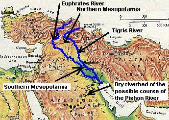
Boston University scientist Farouk El-Baz had long wondered about the pebbles of granite and basalt that are abundant throughout Kuwait. The problem was that these pebbles are not indigenous to the area. The nearest source for these rocks lies in the Hijaz Mountains -- 650 miles to the west in Saudi Arabia! How did the pebbles reach Kuwait? Intrigued by this puzzle El-Baz examined photos of the region taken by satellites orbiting the earth, and to his amazement easily detected a dried riverbed (known today as Wadi Al-Batin) cutting through the limestone of north-central Saudi Arabia. He noticed that the riverbed petered out as it reached the sand dunes of central Saudi Arabia.
The Biblical Archaeology Review (July/August 1996) relates that "when he extended the line of the river across the sand dunes...EI-Baz noticed that the patterns of the desert's sand dunes 'changed precisely when they crossed this line. To the right (southeast), the dunes appear pockmarked, to the left (northeast) they are striated. Sand patterns like these are created by the circulation of the air in the desert, which in turn is influenced by the topography. Thus, El-Baz realised that something beneath the sand was the source of the variations in the sand. He determined that the river ran underground here, along a fault line" (p. 55).
For a long period of time after the recreation of Genesis 1, the river (in places 3 miles wide) dragged granite and basalt from the Hijaz mountains and dumped the pebbles along its fan-shaped delta, which covered two-thirds of modern Kuwait and part of southern Iraq. In memory of the pebble strewn region that led him to the river-bed, El-Baz christened his discovery the Kuwait River.
Now the interesting thing is that this ancient river (which gradually dried up sometime after 3,500-2000 B.C.E.) fulfills all the requirements for one of the rivers of Eden! Notice what Genesis 2:11-12 says: "The name of the first [river] is Pishon; it is the one which ENCOMPASSES THE WHOLE LAND OF HAVILAH, WHERE THERE IS GOLD. And the gold of that land is good. BDELLIUM [FRAGRANT RESINS] and the onyx stone are there" (NKJV).
The Land of Havilah
An important key to determine WHERE the river Pishon ran is the phrase "the gold of that land is good." There is only one place in the area that has such a deposit -- the famous site of Mahd edh-Dhahab, the famous "Cradle of Gold." Located about 125 miles south of Medina in Saudi Arabia, huge fissures on the hillside are the remnants of ancient mining that took place as early as 1000 B.C. Adds the Biblical Archaeology Review, "Rediscovered in 1932 by American mining engineer Karl Twitchell, the mine currently produces more than 5 tons of gold a year" (July/August 1996, p. 57).
Another clue in Genesis 2:11-12 is the phrase "Bdellium and the onyx stone are there." The Arabian peninsula is RICH with bdellium and precious stones. In the Bible dictionary Insight On the Scriptures we find the following: "It [Bdellium gum] is obtained from a tree (commiphora africana) found in NW Africa and ARABIA..." (page 264).
Summing all this up the dictionary goes on to say: "The description of its [Havilah's] resources is considered by some to be TYPICALLY ARABIAN, and it is associated by some WITH A REGION IN ARABIA. On the basis of the Biblical reference to 'the entire land of Havilah,' J. Simons suggests that the term 'Havilah' may take in THE ENTIRE ARABIAN PENINSULA ..."
Further evidence that Havilah was a good portion of the Arabian peninsula is found in Genesis 25:18 and Exodus 15:22: "They dwelt from Havilah as far as SHUR, which is EAST OF EGYPT as you go toward Assyria," and "So Moses brought Israel from the Red Sea; then they went out into the WILDERNESS OF SHUR."
In our articles Is Jebel Musa the Correct Mt. Sinai? and The Mountain of Moses, we show that the Israelites crossed the Gulf of Aqaba -- not the Gulf of Suez -- and that Mt. Sinai is located in the NW corner of modern-day Saudi Arabia (ancient Midian) -- not the Sinai peninsula. The text of Genesis 25:8 therefore shows that the nomadic Ishmaelites ranged from the land of Midian clear across northern Arabia and into Mesopotamia.
Notes the Insight On the Scriptures (page 1045):
"Similarly, when King Saul struck down the Amalekites 'from HAVILAH as far as Shur, which is in front of Egypt' (I Sam.15:7), it would appear that the expression 'from Havilah' points to a portion...of the Arabian Peninsula as representing one limit of the territory in which the Amalekites were centered, while the Wilderness of Shur [on the western coast of NW Arabia].. represented the other limit....Thus it would appear that it [Havilah] embraced AT LEAST the NW portion of the Arabian Peninsula and PERHAPS A MUCH LARGER AREA."
With the location of Havilah clearly delineated by the scriptural references and extra Biblical sources, there can be no doubt that the ancient river bed discovered by Farouk El-Baz from the satellite photographs is none other than that once used by the waters of the River Pishon that flowed through the Garden of Eden to the Persian Gulf.
What About the River Gihon?
The other river mentioned by Moses in Genesis 2:13 was the Gihon. Moses mentioned that it was also "circuitous" and encompassed all the LAND OF CUSH. Where did this river flow from?
While most people and most references to "Cush" in the Bible equate Cush with Ethiopia, this is not always the case. Notice what the Insight On the Scriptures has to say about the land of Cush:
“'The land of Cush' referred to at Genesis 2:13 as the land originally encircled by the river Gihon, one of the four heads of the 'river issuing out of Eden,' is of uncertain location. (Ge. 2:10) The translators of the Septuagint rendered the Hebrew word for 'Cush' by the Greek name Ethiopia in this text. The name Cush did become more or less synonymous with ancient Ethiopia at an early time, yet it CANNOT arbitrarily be said that such is necessarily the case at Genesis 2:13. Josephus, following the rendering of the Septuagint, associated the Gihon River with the Nile" (Jewish Antiquities, I, 39 [i, 3])
“However, the Gihon's having had a common source with the Euphrates and the Tigris rivers certainly does not seem to allow for such identification, unless the global Deluge is assumed to have brought about extreme changes in the topography of the area” (Vol. 1, p. 559).
Ernest L. Martin claims that "true to what Moses said, just to the north and east of Babylon were the mountains of the Cassites (mentioned in the early Mesopotamian records and certainly representing the Cushites). This river [the Gihon] also flowed into the Euphrates/Tigris river system in southern Mesopotamia just as Moses stated. It is today called the Karkheh" (Solving the Riddle of Noah's Flood, p. 14).
This idea is echoed by Delitzsch and Speiser who hold that the term "Cush" in Genesis 2:13 is "the eponym of the Kassites" rather than the name for the region of the Ethiopians in Africa and that "only a Kassite context can accord with the phrase 'in the east' of Genesis 2:8." What about it -- does this hold water?
Notes the Bible dictionary insight On the Scriptures: "Still others suggest that the 'land of Cush' encircled by the Gihon was on the ARABIAN PENINSULA, since the name 'Cushan' is used to parallel 'the land of Midian' at Habakkuk 3:7, Midian being located generally in the vicinity of the Gulf of Aqaba. It is possibly with reference to such an ARABIAN 'CUSH' that Moses' Midianite wife Zipporah is called a 'Cushite."'
This dictionary then goes on to say that "following the breakup at Babel because of the confusion of language, the main body of Cush's descendants appear to have migrated southward. Whether they reached Africa by first CROSSING INTO THE ARABIAN PENINSULA and then crossing over the Bab al-Mandate or whether they settled initially in Africa AND THEN CROSSED OVER INTO ARABIA is uncertain....The name of Cush's son Seba is associated with E. Africa, WHILE THOSE OF HAVILAH, SABTAH, RAAMAH, AND SABTECA ARE GENERALLY ASSOCIATED WITH REGIONS ON THE ARABIAN PENINSULA."
Under the heading "Cushan" this same dictionary relates the following information:
"Cushan appears at Habakkuk 3:7 as paralleling 'the land of Midian' and hence evidently is another name for Midian or relates to a neighboring country. As shown in the article CUSH (No. 2), SOME DESCENDANTS OF CUSH APPEAR TO HAVE SETTLED ON THE ARABIAN PENINSULA; AND THE NAME KUSI OR KUSHIM WAS ANCIENTLY USED TO DESCRIBE CERTAIN ARABIC PEOPLES OF THAT REGION" (pp. 560-561).
Smith's Bible Dictionary adds that "the Cushites appear to have spread along tracts extending from the higher Nile to the Euhrates and Tigris. History affords many traces of this relation of Babylon, ARABIA and Ethiopia" (article "Cush", p. 131).
While Ernest Martin's location of Cush "to the north and east of Babylon" and that "the mountains of the Cassites" represent the Cushites is a possibility, all the evidence points to the "Cush" mentioned in Genesis 2:13 as being somewhere ON THE ARABIAN PENINSULA.
It is also rather interesting that the only water source
that flowed out from Jerusalem was the Gihon Spring. And isn’t it strange that
the only other mention of Gihon in the Bible is in connection with the Garden of
Eden. Is it just a coincidence, or is it vital information? (There are other
springs in the general area today because the area that encompasses the city has
grown considerably, but we are talking about Jerusalem at the time of the
building of Solomon’s Temple, and the Gihon was the only spring within that
city. The Temple was built directly over the Gihon Spring.)
The Gihon Spring flowed from beneath the Temple. The hill of Zion, on which the
Temple was built, was the meeting place between YEHOVAH God and His people
Israel. (Not to be confused with the hill that is called Zion today, where the
Dome of the Rock sits.) Mount Zion in Solomon’s day was the hill where he built
the Temple.
The Nile River and Cush
At the time of creation, as we have seen, a river
flowed from within the Garden of Eden, and then after it left the Garden it
divided into four “heads.” If unimpeded by the works of Hezekiah, or by other
diversions of today, the water from the Gihon would flow through the Kidron
valley and eventually find its way down to the Dead Sea. Yet, many have
suggested that the Gihon, mentioned in Genesis, is the Nile river.
Today, the Aswan High Dam is located at the first cataract of the Nile in
southern Egypt, while the third cataract lies in present-day Sudan -- south of
Egypt. As a result, it would be fair to assume that the Gihon River was located
in the area of what is today southern Egypt and northern Sudan.
The late 2nd century B.C. Book of Jubilees also portrayed the Nile as
being the Gihon. The first century A.D. Judahite historian Flavius Josephus, in
his Antiquities of the Jews, written after 70 A.D., apparently followed
the Septuagint and Book of Jubilees in identifying the Nile with
the Gihon. The early Church Fathers of the Christian Church accepted these
identifications. The Gihon is described as flowing about or through the land of
Cush (Genesis 2:13) which may have suggested to the 3rd century B.C. Judahite
authors of the Septuagint that Egyptian Cush or Kush (modern-day Sudan)
was meant.
To the degree that Gihon might refer to the Nile "in" Cush, it is worth noting
that several maps on the Internet appear to label a village on the Nile as Wadi
el Gineina or Wadi al Junaynah -- south of Lake Nasser and the Aswan Dam. In
antiquity Cush's northern border began at the first cataract of Nile which is
near Aswan (Greek Syene). So the village of Wadi Gineina south of Aswan in
antiquity apparently lay in Cush. Does Gineina (Junaynah) preserve in Arabic the
Gihon which flowed through Cush? And, surprisingly, the Muslims teach that the
Nile was one of the rivers of Paradise!
A map, made in 1831 by Daniel Lizars, shows that the second cataract, which
would have lain in antiquity in Cush, is called el Gianadel (the cataract is
north of Wadi Halfa). It is conjectured that Gian[adel] preserves, in Arabic
Hebrew, the word Gihon. To the degree that Strong's Hebrew and Chaldee
Dictionary defines Gihon as derived from a root meaning "to gush" as in
"water gushing," this is an apt name for the gushing waters of the Nile at the
Cushite second cataract of el Gianadel. It is likely that Genesis' Gihon River
in Cush is then preserved in the regional land area's name of Wady Kenous and
the second cataract of el Gianadel. Titled Arabia with the Adjacent Countries
of Egypt and Nubia, the map is available on the internet at the David Rumsey
Historical Maps Archive.
The Septuagint Bible, written in Greek by Judahites for Judahites at Alexandria,
Egypt circa 275 B.C. in the reign of Ptolemy II, renders Gihon as Geon.
Christians used the Septuagint so it is possible that when Islam conquered
Byzantine Christian Egypt in the 7th century A.D., the Septuagint's Greek form,
Geon, passed into Arabic possibly as Gian (Gianadel).
Translators used the same Greek word in Ecclesiasticus 24:27 in the Catholic
version of the Bible when speaking of the Nile. For those who cannot read Greek,
the word is pronounced ghi' hon -- Geon or Gihon.
Why would the scholars who translated the ancient Hebrew texts into Greek, use
the Greek word Gihon when speaking of the Nile? Perhaps they knew something we
don’t.
The people of Ethiopia have long insisted that the Nile River is actually the
Gihon and, because of this and through their Christianity, have also claimed
“historical rights” over the Nile. They claim that Mary, the mother of the
Messiah, declared that the Nile, the biblical Gihon, was Ethiopia’s.
The only way this could be true is if the terrain had been changed by the great
Flood. And it probably was!
Linking the Gihon Spring to the Nile
If these ancient sources identified the Gihon as
being the Nile, then perhaps we should take another look. Today the Nile flows
from the equator north to the Mediterranean Sea. The Gihon Spring is directly
north of that entrance into the Sea. The Nile flows through a branch of the
Great Rift Valley, being evidence that the terrain had at one time changed,
forming the great gash in the earth that runs from Lebanon down into southern
Africa.
Geologists have suggested that there was a time, prior to the opening of the
“Gates of Hercules” by seismic forces, when there was no Mediterranean Sea. So,
if we eliminate the water from the Mediterranean, we have the flow from the
Gihon matching the northern end of the Nile. This permits the possibility, and
even likelihood, that the Gihon, as mentioned in Genesis, actually had its
beginning at the Gihon spring, which was beneath Mt. Zion.
Now, what is highly significant to this discussion is the possibility of an
underground waterway or channel that exists between modern Israel and Egypt.
Notice what Peter A. Michas says:
"According to the first-century Jewish historian Josephus, there was a popular belief at that time that an underground river joined the Nile River and the Sea of Galilee. An unusual catfish (Clarias lazera) called 'the water raven' by Josephus, is the only representative of its African family found in both the Nile and the Sea of Galilee. Apparently, this underground channel provided a conduit by which this catfish migrated from the Nile to the Sea of Galilee" (The Rod of an Almond Tree in God's Master Plan, p. 67).
Also, according to Mendal Nun in The Sea of
Galilee and Its Fisherman in the New Testament, "This is a unusual fish, the
sole representative of its African family....Josephus Flavius refers to the
catfish by its Greek name of 'Korakinos,' meaning Water Raven; he notes
that it is found in the Nile. In his opinion, this fact supports the popular
belief that there was an underground connection between the Nile and the lake,
and that it emerged from below the ground at the largest spring at Tabgha" (p.
10).
Evidently fishermen today, in the area of the Sea of Galilee, believe that this
underground channel or river does indeed exist, and that it emerges from the
largest spring at Tabgha on the northwestern shore of the sea. If there is an
underground river linking the river Nile to the Sea of Galilee, then it must
pass underground somewhere near to or under the city of Jerusalem -- is there
any evidence of this?
Jerusalem's Underground River
If the Gihon Spring, as the Bible indicates, is the source of life-giving water, is there any evidence to show that it fed an underground river beneath the city of Jerusalem? Writes Peter Michas:
"According to an Israeli Defense film (1990), there is a vast amount of water under Israel. It is also known that an underground river runs under the city of Jerusalem. Local Arabs are aware of this water source. Five such individuals, ranging in age from mid-thirties to about mid-eighties, confirmed to one of the authors (RVM) that a river runs from the north side of the city, under the [so-called] Temple Mount, and to the Pool of Siloam (unto which the Gihon Spring flows). Even so, no one knows the river's origin or final destination" (The Rod of an Almond Tree in God's Master Plan, pp. 69-70).
It seems quite evident that an underground waterway
flows beneath the land of Israel -- including the city of Jerusalem. In addition
to this, it has been shown that an underground channel connects the Sea of
Galilee to the Nile River in Egypt. "In this regard," writes Peter Michas, "the
underground waterway fits the description of the Gihon River which flowed
throughout the land of Cush." He goes on to say that "In fact, a spring located
near Mount Moriah is called the Gihon and represents an essential link to the
Gihon River" (The Rod of the Almond Tree in God's Master Plan, p. 73).
As we have seen, this is entirely consistent with the description of the river
that watered the Garden of Eden. Therefore, without a doubt, this underground
waterway represents the Gihon River, and that it originally shared a common
source with the other three rivers in eastern Turkey.
|
Hope of Israel Ministries -- Expounding YEHOVAH's Truth to the Modern Descendants of Ancient Israel. |
|
Hope of
Israel Ministries |
 |
Scan with your Smartphone for more information |